Nature of Tajikistan
Picturesque Nature of Tajikistan – Country of Mountains and Rivers
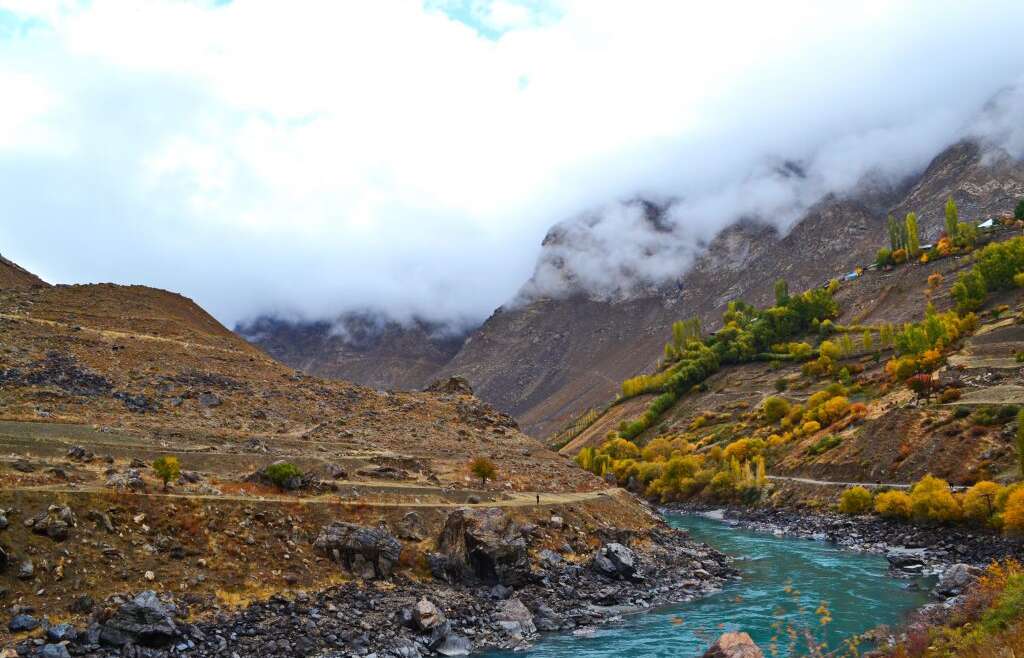
Tajikistan is the land of mountains. 93% of the territory of the republic is over 1000 meters (3,281 feet) above sea level, namely in the mountains of the highest mountain ranges, the Pamirs and Tian-Shan. The names of these ranges says a lot: Pamir translates as the “roof of the world”, and Tian-Shan as “sky mountains”. The highest point of Tajikistan is Ismoil Somoni Peak (earlier called Communism Peak), at a height of 7495 meters (24,590 feet).
The lowest point of Tajikistan is in the north of the country, at a height of 300 meters above sea level. 7% of the territory of the republic consists of plains in the north-west and south-western parts of Tajikistan, which are mainly used for agriculture. The largest two rivers of Central Asia also cross these plains: Syrdarya in the north of Tajikistan and Amudarya in the south.
The flora and fauna of Tajikistan are very rich, but because the mountains are so large, there are mainly mountainous species in Tajikistan. Rare species of animals and birds, including those in the Red Book, live there: goats, snow leopards, storks, hawks and others. The largest reserves of the country are the Tigrovaya Balka, Ramit, Dashtijum and Sarikhosor Reserves. Goitered gazelles, Bukhara deer, tigers, pheasants, Alectoris, jungle cats, wild boars and snow leopards live in tugay wetlands, woods and thickets. Flora is represented by fruit trees as well as plants typical for mountainous area.
Thanks to its complex mountain relief, there are still many areas of Tajikistan that are untouched by civilization. Thus, mountain tours in Tajikistan will allow you to enjoy real, wild natural habitats.
Tajikistan Mountains
Practically the entire territory of Tajikistan, 93% of it to be exact, is located in the mountains. Moreover, half of the land lies at a height of over 3000 meters above sea level. There are the Turkestan, Zeravshan, Gissar and Alay Ranges in Tajikistan, and the entire eastern part of the country is covered by the Pamir Range. The highest point of Tajikistan is Ismoil Somoni Peak, which is 7495 meters high (25,590 feet). 24 more peaks over 6000 meters (19,685 feet) are also located in the country.
Tajikistan’s mountains are quite diverse. They vary according to geological classification, relief, glaciation and other characteristics. The most picturesque mountains are in the west of the country – there are ridged peaks, wide gorges, juniper woods, alpine meadows in the Fann Mountains. The Pamirs are also very beautiful and varied, but they differ because of their severe climate, higher ridges and desert plateaus.
Where there are high mountains, there are glaciers, lakes and rivers. 6% of the territory of the country is covered with glaciers, of which Fedchenko is the most popular. Tajikistan has more than 2000 lakes, most of which are in the mountains, such as Iskanderkul, Bulunkul, Karakul, Yashilkul, Sarez, and Seven Lakes. Many wild rivers start in the mountains, flowing from glaciers.
Fann Mountains, Tajikistan
The Fann Mountains are probably the most beautiful mountain system not only of Tajikistan, but of Central Asia as a whole. It is there where most of our tours are arranged. A variety of routes will allow you to choose from tours for beginners or professionals, and to trek through the blossoming gorges or conquer the rough, snowy peaks.
The popularity of the Fann Mountains is not only about the beauty of its local landscapes, but also about its wonderful climate. The annual precipitation there is 250mm (9.84 in), and the temperature in summer does not rise above 30 degrees Celsius (86 degrees Fahrenheit). The best time for hikes and climbs is between July and September.
The Fann Mountains are located in the western part of Tajikistan, and include parts of the Gissar and Zeravshan Ridges. There are nine peaks with a height over 5000 meters (16,404 feet); Chimtarga is the highest at 5489m (18,008 feet). The Fann Mountains are home to the pearl of Tajikistan – Lake Iskanderkul. The famous Seven Lakes are also located there, falling in a cascade down along a large gorge.
The Russian singer Yuriy Vizbor once visited there and later wrote a song, of which a few lines are excerpted here: “I left my heart in the Fann Mountains. Now I walk heartless in the plains.” It’s hard not to agree with him if you’ve ever been to the Fann Mountains.
Pamir Mountains, Tajikistan
The roof of the world – this is how the Pamir Mountains are often translated. The Pamirs are located across Tajikistan, China, Afghanistan and Pakistan, and are connected with some of the other highest mountain ranges in the world, such as the Tian-Shan, Karakorum, Hindu Kush, and Himalayas. The Pamir Mountains differ because of their severity and high elevations. There are many glaciers, lakes and rivers to be found among the mountains. The environment is tough, though there are places for alpine deserts with a polar climate.
There are few mountains over 7000 meters (22,966 feet) in the Pamirs. The highest point of Pamir is Kongur Tagh (7649m or 25,095 ft), located in the territory of China. Tajikistan has such peaks as Ismoil Somoni Peak (7495m or 24,590 ft), Lenin Peak (7134m or 23,406 ft) and Korzhenevskaya Peak (7105m or 23,310 ft). Apart from these peaks, you can see many other mountains that are over 6000 meters high as well.
There are many lakes in the Pamirs. The largest one is Karakul, located at the height of 3914 meters (12,841 ft) above sea level. Another famous lake of the Pamirs is Sarez: it appeared after an earthquake in 1911, when huge landslide blocked a gorge forming a dam, and the space began to fill with water from the Bartang River. It took 37 years for the lake to form; after that, its area reached 17 square km (6.56 square miles), and the length reached 70 km (43.5 miles). In addition, the Pamirs are home to numerous lakes like Yashilkul, Rangkul and Zorkul, in addition to many smaller lakes.
The Pamirs also have a great number of glaciers, with the Fedchenko Glacier standing out. It is the largest glacier of Pamirs, as well as the longest glacier in the world outside the Arctic and Antarctic.
Lakes in Tajikistan
Lakes in Tajikistan are an integral part of the nature of the country, as are the mountains. They take up only 1% of the territory of the country, but they number over 2000. The largest number of these “pearls” are scattered around the mountains of Tajikistan and located in picturesque gorges. Mainly they were formed when rocks collapsed from the mountains creating natural dams.
The most popular and beautiful lake of Tajikistan is Iskanderkul. It is located in the western part of the country, only a 3 hour drive from the capitol, Dushanbe. It is rather small compared to other lakes in Tajikistan, but thanks to the surrounding Fann Mountains, the landscape there is very picturesque. Moreover, according to a legend, Alexander the Great stopped by this lake, and so the lake was named in his honor.
The largest lake of Tajikistan is Karakul. It is located in the northern-eastern part of the country, at a height of 3914 meters (12,841 ft) above sea level, and has an area of 380 square km (146 sq miles), and stretches 33km (20.5 miles) from north to south and 24km (15 miles) from east to west. Its name translates as “black lake”, though the water there has a bright blue color. The only way to enjoy Lake Karakul is to take a trip along the Pamir Highway.
The youngest and at the same time the most dangerous lake in Tajikistan is Sarez. In 1911, a huge landslide took place in the gorge of the Bartang River after a strong earthquake, thus forming a dam. Each year more and more water fell into the gorge, and its level increased by few meters. 37 years later, in 1948, a snake-shaped lake (70 km long and 2,5-3,5km wide, or 44 miles long and 1.55 to 2.17 miles wide) was formed in the central part of the Pamirs. Today, Sarez’s depth near the dam reaches 480 meters (1,575 ft), and the general volume of water is 17 cubic km. Due to instability of the dam, there is a risk of the natural dam collapsing because of the immense pressure, which would cause huge floods to flow down the Bartang River. Experts say that cities and towns (around 6 million people) on the banks of Bartang, Panj and Amudarya Rivers may fall victim to this catastrophe.
Along with these famous lakes, there are also such lakes as Yashilkul, Zorkul, Nurek and the Kayrakum Reserves, Seven Lakes, and many other lakes in Tajikistan. Each of them is surrounded by the picturesque landscapes of Tajikistan’s mountains.
Glaciers in Tajikistan
About 50% of the glaciation area in Central Asia relates to Tajikistan. There are more than 8,000 glaciers in Tajikistan with the area of 8.5 thousand sq. km. which is more than the area under crops in the Republic. Comparatively large amount of precipitation and low average annual temperatures create in the mountainous regions of Tajikistan such conditions, under which the accumulated winter hard precipitations cannot melt during summer and are collected as snow fields and glaciers; significant differences in physico-geographic conditions stipulate varieties of glaciation types.
Along with compact snow sheets and neve (snow fields) on the slopes of some ranges, as well as large glaciated areas, various types of small glaciers are widely spread. The main part of glaciation is concentrated on the territory adjoining the highest Central Asian peaks: the peak of Communism and the Lenin peak, comprising more than two-thirds of all the glaciation area. In the western regions of the Republic the ranges are not high enough, therefore, though being well moistured, they do not expose developed glaciation. Few glaciers are registered in the Eastern Pamirs due to small amounts of precipitation. A vast area of glaciation is noted in the place of the highest ranges joining: the Range of the Academy of Sciences, the Darvaz, Peter the Great, the Vanch and the Yazgulem ranges. This area is notable for the highest peaks, too, among them are: the peak of Communism, the peak of Eugenia Korzhenevskaya, the Revolution peak. From the Revolution peak to the north, the Fedchenko glacier slides down, it is the largest glacier in Central Asia. (its length is 77 km, the area with the tributaries is 651.7 sq. km. The upper reaches of the glacier with about tributaries are at the 7,480 m height, while its tongue lowers down to 2,910 m. The glacier ice thickness in some places is over 800 m, the ice volume is about 130 sq. km. To the north-east, the Grum-Grzhimailo glacier (142.9 sq. km.) flows down.
In the region of the Communism peak, at the junction of Peter the Great and the Academy of Sciences ranges, a complicated system of large radiating plain glaciers and a vase neve massif, known as “The Pamirs neve plateau” is situated. From the peak of Communism to the south-west, the Garmo glacier which is 114.6 sq. km. slides down; to the north-east, the Bivachni glacier which is 37.1 sq. km. is located, a tributary of the Fedchenko glacier; and at the foothills of the peak, in a narrow deep valley the Fortambek glacier is bedding.
The second significant glaciated area is at the junction of the Zaalai and Zulumart ranges where the Lenin peak is situated. On the slopes of the Lenin peak, a number of glaciers take their origin, the largest of them are: the October (88.2 sq. km.), the Great Sauqdara (53.0 sq. km.) and the Uisu (49.9 sq. km.).
However, the glaciated areas do not involve all the variety of glacial formations. Some ranges are not involved in the glaciated areas which contain a great number of glaciers, such as the glacial formations in Rushan, Muzkol, Shahdara, Hissar and Zerafshan. They are feeding a lot of water springs and comprise the basic stock of mountain glaciers in Tajikistan.
The altitudinal location of the glaciers is not similar and depends both on the climatic conditions and the glacier dimensions. As a rule, the larger glaciers slide down lower than the smaller ones. The averaged altitudes of the glacier lower boundaries are increased from west to east which is connected with the decrease of moisture content in the same direction. The glaciers in the Kafirnihan basin slide the lowest of all (3,650 m), in the Karakul lake basin (4,860 m) their border is the highest.
The glaciers in Tajikistan influence greatly the formation of flow and regime of rivers, as they are, first of all, the moisture accumulators for numerous rivers feeding; and secondly, they are natural flow regulators, giving up, in the process of melting, their water stock to the rivers in hot season when the need for water for agricultural purposes is especially high.


