National Parks in New Zealand
New Zealand’s 13 national parks showcase more than 30,000 square kilometres of diverse, natural scenery ready to explore by foot, boat, car or air.
Spend time in New Zealand’s national parks and you’ll begin to understand the soul of this place. Our national parks are treasured and preserve our natural heritage, forests, wildlife and landscapes, close to – if not exactly, as it was before people arrived here.
TONGARIRO NATIONAL PARK
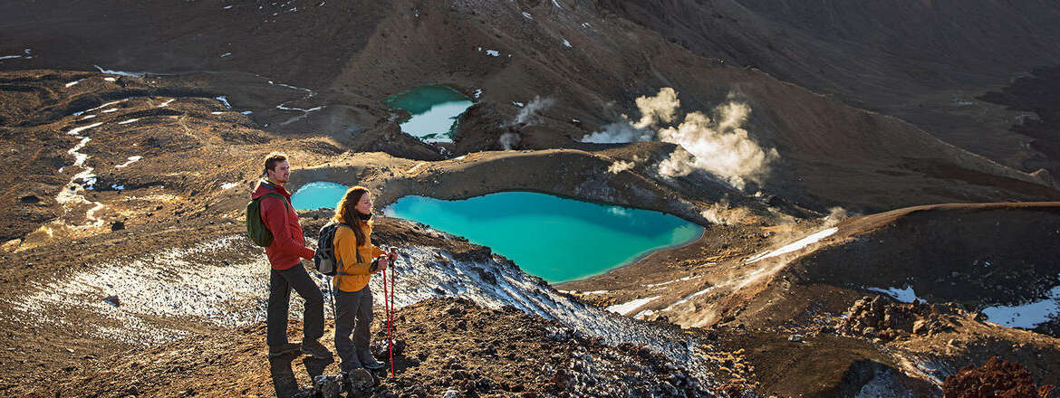
Centred upon three volcanoes –Tongariro, Ngauruhoe and Ruapehu –Tongariro National Park is home to some of New Zealand’s most dramatic landscapes.
Tongariro became New Zealand’s first national park in 1887. Just over one hundred years later, the park was awarded dual UNESCO World Heritage status for both its cultural significance to the Māori people, as well as its outstanding natural features.
The 80,000-hectare park is a spectacular showcase of volcanic wonders including emerald lakes, old lava flows, steaming craters, colourful silica terraces and peculiar alpine gardens. It is an environment of staggering beauty and diversity.
Three volcanoes – Ruapehu, Ngauruhoe and Tongariro – mark the southern limits of the Taupo Volcanic Zone, the horseshoe-shaped series of volcanic phenomena that make up the Pacific Ocean’s ‘Ring of Fire’.
Volcanic activity started here around two million years ago and continues to this day. Ruapehu and Tongariro, which date back before the last ice age, are two of the most active composite volcanoes in the world, with Ruapehu last erupting in 1996. Ngauruhoe – geologically considered a ‘vent’ – last erupted in 1975.
FIORDLAND NATIONAL PARK
One of the most dramatic and beautiful parts of New Zealand; the power of Fiordland’s scenery never fails to enthral travellers. This remarkable natural environment features stunning fiords, spectacular waterfalls and snow-capped peaks.
Ancient rainforest clings impossibly to the mountains; waterfalls tumble hundreds of meters into massive fiords; shimmering lakes and granite peaks look the same today as they did a thousand years ago.
RAKIURA NATIONAL PARK
Many people think of New Zealand as two islands, when it is actually three. Subantarctic Stewart Island lies 30 kilometres south of the South Island. Stewart Island or Rakiura has a land area of nearly 2000 square kilometres, and 85% of it is included within the boundaries of Rakiura National Park.
The most recent addition to New Zealand’s national park portfolio, Rakiura is an enchanted world of unmodified ecosystems and habitats. From dense coastal rainforests and freshwater wetlands to vast sand dunes and granite mountain ranges, the park provides an exceptional opportunity to see native wildlife and primeval landscapes.
WESTLAND TAI POUTINI NATIONAL PARK
Release your inner explorer in a pristine national park that offers a wide selection of tempting and impressive terrain. This national park is known for its “glacier country”. In some places, huge tongues of ice extend all the way back down to near sea level. 3000m peaks tower over lowland rainforests that reach all the way to the edge of the Tasman Sea. It’s an area also blessed with contrasting tussock grasslands, coast, lakes, rivers and wetlands.
Embark on kayaking adventures on Lakes Matheson and Mapourika and explore vast rivers and coastal lagoons. Take an easy walk to the base of the fascinating Fox and Franz Josef glaciers and look for some of New Zealand’s rarest native birds in the rainforests and wetlands.
The mountains of the Southern Alps are revered by the local Maori people (the Ngai Tahu tribe) as their ancestors. The whole coastal environment is also of considerable importance to these people, both spiritually and for the food and resources it provides.
MOUNT ASPIRING NATIONAL PARK
Stretch your legs and feed your soul in this beautiful wilderness of native forests, towering mountains and long river valleys. Named for Mt Aspiring, one of New Zealand’s highest peaks, this park is a dreamland of mountains, glaciers, river valleys and alpine lakes.
A hiker’s paradise, Mount Aspiring National Park offers a large number of short walks that are mostly concentrated at the end of the park’s access roads.
Longer hikes through beautiful valleys, with options to traverse mountain saddles, include the Routeburn, the Dart/Rees River circuit, Greenstone/Caples and the Wilkin Valley tracks. In summer, it’s possible to walk from one valley to another over spectacular mountain passes. Shorter walks include Routeburn Nature Walk, Haast Pass Summit, Lake Sylvan near the lower dart River and the Blue Pools Walk. A highlight of any South Island adventure, the 30-minute Blue Pools Walk leads through silver beech/tahina forest and over a swing bridge to a viewing platform overlooking magnificent crystal-clear pools at the mouth of Blue River.
In the past, Maori trekked through the region on their way to the pounamu fields of the west coast; Europeans visited to map, name and explore geographical features of the area; settlers attempted to farm and mine some of the valleys – the relics have blended into the stunning scenery.
AORAKI MOUNT COOK NATIONAL PARK
Mt Cook, the tallest mountain in New Zealand, helped Sir Edmund Hillary to develop his climbing skills in preparation for the conquest of Everest. Aoraki Mount Cook National Park is home of the highest mountains and the longest glaciers. It is alpine in the purest sense – with skyscraping peaks, glaciers and permanent snow fields, all set under a star-studded sky.
According to Ngāi Tahu legend, Aoraki and his three brothers were the sons of Rakinui, the Sky Father. While on a sea voyage, their canoe overturned on a reef. When the brothers climbed on top of their canoe, the freezing south wind turned them to stone. The canoe became the South Island (Te Waka o Aoraki); Aoraki and his brothers became the peaks of the Southern Alps.
PAPAROA NATIONAL PARK
Discover amazing pancake rocks, lush native forests, delicate cave formations and limestone canyons – all in one beautifully diverse national park. This fascinating national park, towards the northern end of the South Island’s west coast, runs all the way inland from the ocean to the rugged ice-carved Paparoa Mountain Range.
In the interests of science, the boundaries of the park were carefully established to encompass a complete range of landscapes and ecosystems – from the granite and gneiss summits of the Paparoa Range down to the layered rock formations of Punakaiki.
By following the historic Inland Pack Track(opens in new window), formed originally by gold miners, visitors can discover some of the park’s most special places. Camping under a natural rock shelter – the Ballroom Overhang – is an unforgettable experience.
ARTHUR’S PASS NATIONAL PARK
The highest pass over the Southern Alps, Arthur’s Pass was historically known to Maori hunting parties as a route between east and west. The eastern side of Arthur’s Pass National Park is characterised by wide, shingle-filled riverbeds and vast beech forests. The western side of the park, where wet weather is more common than dry, has deeply gorged rivers flowing through dense rainforest. Down the middle of ‘the great divide’ is an alpine dreamland of snow-covered peaks, glaciers and scree slopes.
Most people arrive in Arthur’s Pass National Park by road – a spectacular piece of extreme civil engineering involving viaducts, bridges, rock shelters and waterfalls redirected into chutes. When Arthur Dobson first encountered the precipitous Otira Gorge, the pass was almost impassable – he had to leave his horse at the top and lower his dog on a rope.
Another way to experience Arthur’s Pass is on the TranzAlpine Train from Christchurch. After your scenic train journey you can spend the day exploring Arthur’s Park National Park, walk through New Zealand native forest, enjoy lunch at a cosy cafe, and look for cheeky kea. A return train departs Arthur’s Pass at 4pm and arrives back in Christchurch at 6pm.
ABEL TASMAN NATIONAL PARK
Abel Tasman National Park is New Zealand’s smallest national park- but it’s perfectly formed for relaxation and adventure. A coastal paradise that you can walk through or explore by cruise boat, sailing catamaran, water taxi or sea kayak, visitors love the way the Abel Tasman National Park mixes physical exertion with beach life. Bursts of hiking or paddling are punctuated by sun bathing, swimming and sedate snorkelling.
Those who do crave home comforts can stay in luxurious lodges, but sleeping under the stars is regarded as the ultimate way to experience the spirit of the Abel Tasman.
NELSON LAKES NATIONAL PARK
The Nelson Lakes National Park is an enchanting alpine landscape of rugged peaks, forests and stunning glacial lakes. A compact area of mountain ranges separated by forested valleys, the Nelson Lakes National Park is home to the beginning of the awe-inspiring Southern Alps.
Promising everything from easy lakeside walking tracks to challenging alpine hikes, this national park has something on offer for everyone.
The beautiful alpine lakes of Rotoroa and Rotoiti form the heart of this 102,000 hectare national park. Both are surrounded by steep mountains and fringed to the shore by native honeydew beech forests, which feed a variety of tuneful nectar-eating native birds.
In Maori mythology the lakes were created by the great chief Rakaihaitu digging holes with his ko (digging stick). One hole became Lake Rotoroa (large waters) and the other became Lake Rotoiti (small waters).
The nearby village of St Arnaud is a comfortable, well-equipped base for visitors.
KAHURANGI NATIONAL PARK
Diverse and wild, Kahurangi is an enticing world of marble mountains and peaceful, palm-fringed beaches. In the Maori language, Kahurangi means ‘treasured possession’, a clue to the attractions of New Zealand’s second largest national park. Within its boundaries lie some of the oldest rocks, strangest plants and rarest birds in the country.
While much of the park is untracked wilderness, other areas are laced with a network of walking tracks that allow you to explore high plateaux and coastal palm forests. The Heaphy Track is the park’s most famous and accessible treasure, followed by more than 4000 walkers each year. A ‘Great Walk’ by every definition, the track covers 78km of subtropical rainforest, tussock high country, river valley and coast. For hundreds of years the route was used by local Maori tribes on their way to the pounamu (greenstone) resources of the west coast.
EGMONT NATIONAL PARK
Egmont National Park encompasses the huge volcano Taranaki and offers lush waterfalls, rainforests and mossy swamps. Mount Taranaki is New Zealand’s most perfectly formed volcano. It is around 120,000 years old and last erupted in 1775 and volcanologists agree that the mountain is ‘dormant’ rather than extinct. Often described as ‘New Zealand’s most climbed mountain’, Mt Taranaki provides non-mountaineers with an achievable summit challenge.
At lower altitudes you’ll walk through tall rimu and kamahi trees; higher up the volcano, sub-alpine shrubs and herb fields are found above the snow line. Lush rainforests can be found on the mountain’s slopes and are a result of the area’s high rainfall and mild coastal climate.
The walking track(opens in new window) network in this national park is extensive, ranging from a 15-minute stroll along the Kamahi Track to the three-day Pouakai Circuit. There’s a veritable maze of tracks around the Dawson Falls area, including the walk to Wilkies Pools, a series of eroded rock pools connected with gentle waterfalls.
Taranaki is linked by legend to the mountains of the central North Island. As the story goes, Taranaki once lived with the other volcanoes of the central plateau – Tongariro, Ruapehu and Ngauruhoe. When he made flirtatious advances towards a pretty hill named Pihanga, Tongariro erupted in a jealous fury. Taranaki fled to the west, gouging out the Whanganui River on his way. Today Taranaki is still venerated and its summit is sacred to the Maori people of the area.
There are three entry points to the park – Manaia Road, Egmont Road and Pembroke Road.
WHANGANUI NATIONAL PARK
This national park is home to the mystical Whanganui River, New Zealand’s longest navigable waterway. Located in the central North Island, the park was created to protect the upper reaches of the Whanganui River. Once an important transport route for both Maori and early European settlers, the river flows from Tongariro National Park to the Tasman sea through wild lowland forests.
The 290km-long Whanganui River turns on a great paddling adventure. Taumarunui is the starting point for most canoe or kayak safaris; with easy-to-access huts and campsites dotted along the riverbanks. An overnight stay at Tieke Marae is a special highlight. Run by local Maori, the marae is a chance to see local customs in action.
Jet-boating is another way to enjoy this national park. From Pipiriki you can journey up the river to the Bridge To Nowhere, which is all that remains of Mangapurua, an isolated settlement that was abandoned in 1942.
The land surrounding the Whanganui River is remote and rugged and full of the melodies of abundant native birdlife. The small neighbouring towns of Ohinepane and Whakahoro provide further access to hiking and canoeing experiences within the park.


